Recently I wrote about the streetcar genesis of Auckland’s suburbs. All of the historic tram line streets still serve as key movement infrastructure primarily providing central city access.
It’s intriguing to imagine what city life would have looked like 100 years ago. While it may not bear much resemblance to city life in these videos of San Francisco or Barcelona, it is likley that there was more public life along the streets and plenty of movement from one side of the street to the other.
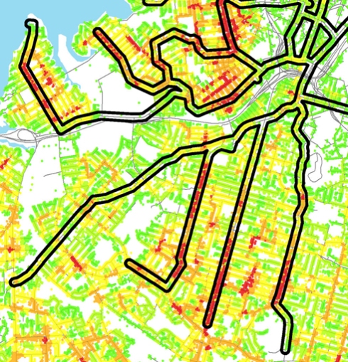
The streetcar fabric is inherently spatially integrated since it was designed primarily for a transportation system based at least in part on pedestrian movement. Below is a test of the ‘centrality’ of the Auckland suburbs using the recently developed Urban Network Analysis toobar for ArcGIS, by MIT’s City Form Research Group. The software developers explain the concept of centrality studies “[as helping to] explain, for instance, on which streets or buildings one is most likely to find local commerce, where foot or vehicular traffic is expected to be highest, and why city land values vary from one location to another.”
The red dots indicate a higher score of “closeness”, basically places are close to other places via connecting streets within a given distance threshold (in this case 400m to model walkability). The black outlines show streetcar lines, revealing the natural relationship of closeness with the underlying street grid and street car fabric. Note too the how the motorway development appears to defeat closeness.
This map gives a false impression, however. I believe that there is not nearly as much closeness or spatial integration occuring along these arterials today. Over the last several decades the priority of movement has been given to through traffic to the city center, at the detriment to local trips, especially those made on foot. In addition to high traffic volumes and excessive speeds when congestion doesn’t prohibit it, there are several other design conditions that limit local connectivity: poor pedestrian design at intersections, limited protected crosswalks or traffic signals, and insensitive public transport conditions (namely speeding buses along street edges).


